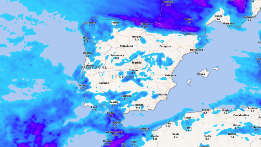
In the last few days the weather has given a lull to much of the country with some stability, except in Canary Islandswhere persistent rainfall has been recorded. However, throughout this week a polar jet will gather strength and direct several squalls towards Spain, according to Meteored. Specifically, the State Meteorological Agency (Aemet). forecasts that a front will enter the Peninsula this Tuesday and will leave rain, especially in the extreme north, although in the following days it will extend to other areas with snowfall in mountains.
In the Canary archipelago heavy and persistent showers are expected this Tuesday and, in fact, the Aemet has activated rainfall alerts on five islandsOrange warning in La Palma, for accumulated rainfall of 30 l/m² in one hour, and yellow in Tenerife, Gran Canaria, El Hierro and La Gomera for records of 20 l/m² in one hour. However, rainfall will decrease by the end of the day. On the other hand, in the coast of Cadiz there is yellow alert for storm.
At the same time, the polar jet stream will pick up speed and a front will approach from the north of the peninsula, with the probability of precipitation and very strong gusts of wind in Galicia and the Cantabrian area. There may also be some heavy showers around the Strait of Gibraltar, while in inland and mountainous areas there will be some isolated showers. In the rest, stable weather is expected with morning cloudiness in large areas that, in general, will dissipate.
The spokesman of the Aemet, Rubén del Campo, has informed that temperatures will be mild for the season of the year throughout the week and will tend to fall for much of the Atlantic slope. However, the mercury will rise in most of the Mediterranean communities: in Barcelona will exceed 20 degrees and in Valencia, Malaga and Alicante will be around 25.
A cyclogenesis will be formed on Wednesday
A change in the weather will occur on Wednesday with the formation of a cyclogenesis in the northern Cantabrian Sea, in the contact zone between polar and subtropical air, which will be driven eastward by the polar jet. The term cyclogenesis refers to the creation or formation of a squall in areas where air masses of different temperature and density meet, generating instability.
Meteored points out that a front associated with the low will leave heavy precipitation in the Eastern Cantabrian, Navarra and in the western sector, division and the French side of the Pyrenees mountain range. It will rain more lightly in Galicia and the rest of the Cantabrian slope. This day will be calmer in the Canary Islands, although some showers cannot be ruled out and temperatures will rise in the archipelago.
Likewise, it will snow in mountains from about 2,000 meters, with the elevation dropping throughout the day to about 1,500 meters. The wind will blow with strong gusts especially in the Cantabrian and Mediterranean coasts and there will be a daytime temperatures will drop in much of Spain, although there will still be a mild atmosphere, and in the Mediterranean will continue with the thermometer in excess of 20 degrees.
Between Thursday and Friday, a new, more active front will arrive, which will leave widespread and locally heavy rainfall in the northern third.specifically in Galicia, Cantabrian slope, north of Navarra and the French side of the Pyrenees. The rains may spread to other areas of the rest of the Peninsula, especially in the mountains, and also to the Canary Islands, with a drop in temperatures in the southern half.
The rains will be spreading across the center and will hardly reach the southern half, where they will be weak and isolated, as it is usual in this type of situations. Temperatures will drop in much of the country, snow will fall in the main mountain systems of the northern peninsular and the wind will continue with very strong gusts in the north and east of the Peninsula.
Friday and the weekend, the Peninsula will be exposed to the passage of Atlantic fronts. A squall will deepen rapidly, probably explosively, in the Atlantic, with rainfall in the north and west, mainly affecting Galicia while the rest will have some isolated precipitation.
For the final stretch of the week the following is expected “a marked rise in temperatures”, according to the Aemet spokesman, which would lead to a very mild environment for the time of year, with weather that will be generally calm in the Canary Islands.
