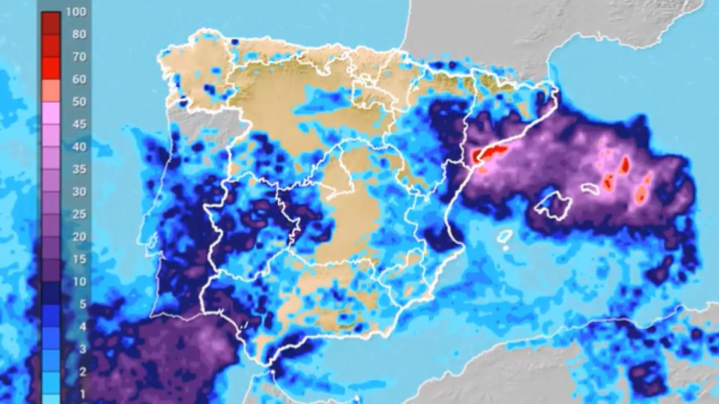
The isolated trough at high levels (DANA) that has so far left 205 dead is losing intensity, but will continue to leave heavy or persistent precipitation. at least until Saturday in several areas of the peninsula and the Balearic Islands and only a transition to more stable weather will begin on Sunday..
The State Meteorological Agency (Aemet) has warned this Friday that “the dana continues over Spain” and the adverse situation will remain throughout the weekend, so it has called for caution and consult the weather forecast and the warnings in force, after the disaster caused by its passage through the Valencian Community, Andalusia and Castilla-La Mancha.
From Meterored (eltiempo.com) it is also predicted that this weekend the DANA will be “reabsorbed by the general circulation”, but they warn that “there will still be locally heavy rains“. Precipitation, they added in a message in X, “will tend to be less in the southwest”, although “in points east-northeast and Balearic Islands will still be strong”, so they ask “not to lower the guard”.
This Friday the precipitations will continue in the Valencian Community, in the southwest quadrant of the peninsula, southwest of Castilla y Leon, Aragon, Catalonia, Levante and the Balearic Islands, not ruled out in large nearby areas, reported the Aemet that has activated for today warnings in Valencia, Andalusia, Balearic Islands, Catalonia and Extremadura.
In different areas of the coast of Huelva the following are active red alerts (extreme risk), orange (significant risk) and yellow for accumulated precipitation forecasts of 140 liters in twelve hours and is expected to continue with “high intensity” in the warning areas during the next hours.
Likewise, the orange warning has been activated in the islands of the balearic archipelago where up to 120 liters per square meter can be registered in a few hours; orange is also active in Catalonia, and yellow in the Valencian Community and Extremadura.
According to the Aemet, locally strong and/or persistent showers and storms may be recorded in the far west of Andalusia and in the lower Ebro and the Balearic Islands, without ruling out areas of the southern slopes of the western Central system.
The Saturdayinstability will continue in the eastern Mediterranean area and in the southwest of Andalusia, with forecast showers and thunderstorms that can still be locally strong and / or persistent in Tarragona, Castellón, Valencia and the Balearic Islands, without ruling out that they are recorded in Cadiz and the west of Malaga, Murcia, both plateaus and mountains of the far north.
The maximum temperatures will rise in the southwest peninsular, will fall in the Cantabrian coasts and environment of the eastern Iberian-Basso Ebro, and there will be little change in general in the rest, while the minimums will register slight decreases, and there will be possible weak frosts on the peaks of the Pyrenees and Sierra Nevada.
The SundayThe Aemet forecasts a transition to greater stability, but showers will persist in areas of the northeast, and may be locally strong in areas of the northwest. Tarragona and CastellónThe mid-low Ebro, Catalan coasts, the Strait of Gibraltar and the Balearic Islands, without ruling out other areas of the eastern third.
In the Canary Islands some intervals with the possibility of weak and scattered rainfall in the north of the mountainous islands and light winds are expected.
The temperatures will rise in the west of the peninsula and fall in the rest of the peninsula, while in the archipelagos there will be little change. There will be predominant winds, generally light, from the east on the Peninsula and the Balearic Islands.
Next week
According to the Aemet forecast, it is likely that next week instability will remain and continue for most of that period, with precipitation from Monday in the west of the peninsula.
Precipitation will affect the Mediterranean area next week, with showers and possible storms that will be more likely and intense in Tarragona and Castellón.
According to the agency, although there is uncertainty about the situation as the week progresses, instability is likely to continue in the Mediterranean area. and it is not discarded that it could extend towards the interior of the eastern third of the peninsula towards the end of this weekly period.
Temperatures will be maintained and will register slight changes, with rises on the first days and decreases from Friday onwards. Light winds will blow predominantly east and south.
In the Canary Islands, winds are likely to blow from the east, with the possibility of light rainfall in the north of the mountainous islands.
