The DANA most catastrophic of the 21st century is leaving at the end of the country, after having caused a unprecedented tragedy which has been especially felt in the province of Valenciaand has so far left 215 dead, between that province and the provinces of Cuenca, Albacete and Malaga. On Monday the cold drop gave its last blows in Cataloniawhere the red alert was activated for “maximum danger” due to torrential rains, and for this Tuesday the phenomenon can be considered over.
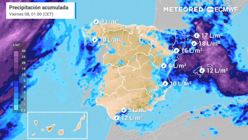
In a manner unrelated to the DANA, as of this Tuesday. instability will continuewith heavy rainfall that will persist in several parts of the Peninsula, with two main focuses: the northeast of the peninsula with several warnings for rain and the arrival of the storm Patty to the west from the Atlantic.
Warnings in the northeast, especially in Catalonia.
On the one hand, the State Meteorological Agency (Aemet). has activated yellow warnings in Catalonia, Extremadura y Aragon for rains that will leave up to 20 liters per square meter in one hourespecially in mountain areas and on the Catalan coast, where there will also be strong storms.
Specifically, these are the provinces of Huesca, Tarragona, Barcelona, Girona y Cáceres the only ones with warning for precipitation and thunderstorms. Huesca (Aragón) and Cáceres (Extremadura) have had a rainfall warning during the morning, while the three Catalan provinces mentioned are warned by showers and thunderstorms until the end of the day..
It is expected, therefore, that the situation will persist of instability in the northeast peninsularwith showers and thunderstorms that will impact Catalonia, Pyrenees y Castellón. In turn, it could also fall locally strong in the Aragonese Pyrenees, coasts and southern Catalonia, as well as in the Empordà at the end of the day.
Likewise, occasional showers could also occur in other points of Navarra, northern Aragon and Balearic Islands. Meanwhile, there will be stable weather in Canary Islands with a predominance of light cloudy or clear skies.
A new front from the west: storm Patty
The AEMET also puts the focus on the west peninsularas it is expected to be seen is exposed to the Atlantic circulation and that a front, the Storm Pattyleaving precipitation in the south of Galicia and west of Andalusia, Castilla y León y Extremadura.
These fronts occur in areas of warm water, with favorable conditions for the development of storms.. Wind intensity is usually low, but rainfall can cause flooding.
In fact, the forecast picks up probabilities that the rainfall in the far north of the latter autonomous community to become persistent and locally heavy. Also, it is not ruled out that showers may fall weakly in other parts of the northwest quadrant and environment of the Iberian.
Temperatures and winds
With regard to the temperaturesthe maximums will increase in the interior of the eastern peninsular, Galicia and the Canary Islands, will decrease in the northern plateau and no major changes will be recorded in the rest of the country. In turn, minimum temperatures will rise in the northwest quadrant of the peninsula, mountains of eastern Andalusia and east of the Canary Islands. In the rest, decreases will predominate.
Also, the state agency indicates that there is a possibility that there could be weak frosts on the summits of the Pyrenees and Sierra Nevada.. The provincial capitals with the highest temperatures will be Santa Cruz de Tenerife with 26ºC; Palma and Bilbao with 25ºC; and San Sebastián, Girona, Murcia, Las Palmas de Gran Canaria and Valencia with 24ºC.
For the rest, AEMET points out that the following will prevail light winds in generalnorth and east components in the Mediterranean area, more intense easterly in the Strait. In the rest, there will be south or variable component in the rest, more intense on the coasts of Galicia and eastern Cantabrian where it will turn east. At the same time, moderate trade winds will blow in the Canary Islands.
